June 24th, 2012

Today is the final day of our trip. We left Rhode Island and headed back to the Richard Stockton College of New Jersey. 

Dan, tired from the trip.

June 23rd, 2012

It is day 14 of our trip and we are visiting the Rhode Island Nuclear Science Center. We are meeting with Jeff Davis, Assistant Director of the facility. This facility is home to a
2-megawatt
, light water cooled, pool type reactor. To start off, we learned about the nuclear science and condensed matter physics used here to create nuclear energy.


atom diagram
 The physicists at this facility are interested in what's going on inside the nucleus. Isotopes are used to keep track of the different types of hydrogen atoms. A handful of isotopes undergo a reaction to become the reactor fuel used in this facility. The reactor fuel used most often in this facility is Uranium-235. Basically, they are creating fission. They use Boron to control the fission reaction and make sure it is not our of control. There are three types of "neutron generations" possible during this fission reaction; 1) sub-critical, ) critical and 3) super-critical.  The reactor fuel used in this process is put into the form of plates. The plates are put into an arrangement of 14 control rods and by raising or lowering them, the physicists can control the entire nuclear reaction. The begin the process at the sub-critical level, then move to critical, and finish with super-critical. Going in this order allows for the neutron population to go up and power is created.


Every year, the Center checks the Boron levels in the reactor, but they have not changed since the 1960's. The water used in the reactor is cleaned thoroughly before being used, so that it does not become radioactive. The water used is also not dumped anywhere but rather dissipated into the air. This reactor has multiple uses such as neutron capture therapy, which focuses radioactivity on the alpha neutrons that are causing cancer in someones tissue. This is a relatively new method of treatment and more research must be done on it. They are having trouble with keeping the radioactivity concentrated on only the cancerous tissue. Neuron scattering is another way this reactor is used and provides material structure information. This third use of the reactor is neutron activation analysis. It is used for determining the types and concentration amounts of elements present in solid, liquid, or gaseous samples. This is used in commonly in atmospheric chemistry when trying to identify chemicals found in the air. This reactor can also be used for biomedical cell tracking, kidney failure diagnostics, and stem cell research. All of this is very probabilistic because there is a set number of reactions that can occur in all of these processes. The physicists just manipulate the process as much as they can to get the outcome they want. 

The Center has an incredibly small staff of eight people, but there are multiple areas of focus between them. Some study engineering, physics, or even oceanography. The nuclear development field is not doing very well, almost everyone within the field is within five years of retirement. There is a need for people to enter this field and money available to help people do so. The University of Rhode Island actually has pretty up and coming nuclear engineering program. This facility does not use fuel very much or very often. The Federal government lends them fuel. The facility does not use all of the valuable components of fuel so when they are finished with it they return it to the government. This facility seems to not produce much waste or use anything wastefully. 

Getting to see the actual reactor (pictured above) was really spectacular. To me, it seems like a generally safe operation that is used mostly for beneficial research in the medical field. This facility, and surely other ones alike, face a lot of negative accusations because they are nuclear. People can only seem to focus on what has happened at other nuclear facilities and the negative impacts they have had. It seemed as though Jeff was frustrated by this and is trying to educate people on the safe and effectiveness of nuclear reactors. This is a very small nuclear facility so it is not really expected to have a huge environmental impact. 

June 22nd, 2012

Today, the 13th day of our trip, we departed from Boston, destined for Cape Cod, Massachusetts. On the docks of Aunt Lydia's Cove, we met with Ray Kane of the Cape Cod Commercial Fishermen's Association. The goal of the Association, as defined by Ray, is to make sure the fisherman of Cape Cod are catching fish and making profit. How do they do that? By promoting the interests of the local fishing community while still protecting our oceans. The Association is currently in the process of changing their name, and Ray wants the word 'sustainable' to be incorporated in the new one.

 Cape Cod was originally a hook-only town. Then, in 2006, gillnetting became an acceptable method as well. Using gill nets is an incredibly efficient way to catch fish. It is, in fact, so efficient that the use of gillnets is heavily monitored and regulated by fisheries management and enforcement agencies.
 
 Unfortunately, there are still some complications with gillnetting and the people who use this method. Although practiced by some fishermen correctly, when implemented the wrong way, gillnetting can have serious repercussions. By-catching is a problem brought on by gillnetting, and is defined as when a species that is not targeted for catch gets caught in a gill net. Gill nets can be more than two miles long, which seems to be just asking for something besides the targeted fish to be caught.

As an intern at the Marine Mammal Stranding Center, I can confirm that situations exactly like what is pictured here, is a common occurrence. We have seen countless seals, sea turtles, and other aquatic species, mangled in fisherman's nets. Fishermen have been known to leave gill nets (or pieces of them) behind. Depending on the material they are made from, these nets may take ages to decompose. The nets we most commonly find animals twisted in at the Stranding Center are monofilament, which takes over  600 years to break down.                      

Ray explained that the Cape Cod Fishermen's Association uses as many precautionary tactics that they can. The mesh size, twine strength, as well as net length and depth are all closely regulated to reduce the bycatching of any non-targeted species. Unfortunately,  hauling in the gill nets is an area of concern as well. When gill nets are hauled in, they can get drag across the seafloor or get caught on structures like coral or rocks. Ray explained that observers (trained biologists who collect data on fishing
activities on board commercial vessels) actually go aboard with the fishermen to make sure they respond to situations like this correctly. It is good that all of these precautions are in place, but fishermen need to really grasp the concept of how much destruction their carelessness can cause. Gillnetting is also suspected as a factor in the depletion of fish stocks. Given that it is so efficient in catching them, this does not seem surprising. The use of GPS technology has also contributed to depletion of fisheries, because it makes finding fish so easy. If we are not careful with how we regulate this activity, it could really hurt us in the future.


The fishing fad in Cape Cod right now is skates, which we saw pounds of being brought in while we visited the docks. Ray explained them as a sustainable fish, but I can't say I fully
believe that. 
 
The skate population in the North East is in abundance. Skate has become an
increasingly important fishery only because the populations of the other bottom-dwelling fish in the area (such as cod and haddock) have declined. A fishing vessel is allowed to bring in 2,600 lbs of skate a day. Sure, skates are in abundance now, but so were cod and haddock at one point. Why do you think the populations of those fish  dropped so low? Because they were over fished. Skate are destined to have the same future as the other bottom-dwelling fish if fishermen continue on this path. Just because a fish is in abundance, does not necessarily make it sustainable. They need to reduce the rate at which they are extracting these fish before it is too late. According to Ray, overfishing is not the fault of fishermen, but rather the national and state fishery organizations who mismanage.


As we watched a fishing boat unload the pounds of skate it had caught, you couldn't help but notice the number of seals in the harbor. A few of them hovered next to the fishing boat, hoping to snag a stray skate or two. They were everywhere! Seals are currently protected under the Marine Mammal Protection Act, which I advocate daily at my internship. Under this Act, the hunting, killing, capture, and/or harassment of a marine mammal is illegal. Humpback whales are also protected under the Endangered Species Act. These causes complications for the fishermen of Cape Cod. If a seal or whale gets caught in a fishing net, the fishermen are supposed to call it in to an observer and let them handle it. Unfortunately, this just makes a lot of extra work for the fishermen, they would rather just cut it loose themselves and get back to fishing. This results in an inaccurate estimate of total marine mammal and sea turtle bycatch. Even well planned monitoring programs may underestimate marine mammal bycatch. An observer is not put onto every fishing boat that leaves the docks, so therefore every bycatch is not recorded. The data that has been collected on bycatching shows that, in the United States, most observed bycatch occurs in gill-net fisheries. To a fishermen like Ray Kane, these seals and other marine mammals have recovered, so therefore they don't need our protection.

Menhaden is known as the most important fish in the sea. Why? Tiny, oily menhaden provide food for essential fish such as striped bass and for birds such as osprey, bald eagles and brown pelicans. Without menhaden, it is said that the ecosystems of the Atlantic Ocean, and other coastal water ways, would come crashing down.

http://www.menhadendefenders.org/wp-content/uploads/2011/08/ThreeDecadeDeclineGraph.jpg

As you can see in the chart above, menhaden have been on a steep decline. This is due, with no surprise, to over fishing. The Atlantic States Marine Fisheries Commission voted 14 to 3 to cut the amount of menhaden that can be harvested annually from 183,000 metric tons to 174,000 metric tons. The commission must now draft and vote on a plan to implement the new rule, which is likely to become effective in May 2013. Ray Kane is pleased with the changes concerning menhaden, and believes that they should be preserved. Especially since most of the over fishing is done by one, single company. In 2010, Omega Protein Corp. took 160,000 metric tons of menhaden — 80 percent of the 450 million fish harvested last year. 
The company crushes the fish into meal to feed livestock and farmed fish around the world. Omega felt that the Commission's decision was harsh, and that water quality and other environmental factors were just as liable for the fish decline. Agricultural run off is a leading contributor to water quality degradation. So, ironically, those livestock Omega are feeding these menhaden to, is probably contributing to that terrible water quality.

The quality of the environment is what is going to decide how successful these fishermen are. Oceans are an amazingly intertwined system, so keeping all of them in pristine condition is crucial. Ray explained how even the fishermen of Cape Cod were feeling the effects of the Gulf oil spill. 

The diagram above shows how the currents of our water ways work together. The Gulf stream moves right up towards North Eastern America, which is why Cape Cod fishermen are seeing changes. Ray claims that the Federal government knows that the water is dangerous, but they don't want to destroy an entire industry of fishing. Debris and radiation from the earthquake in Japan are also showing up in United States waters. Fish who travel from the waters of Japan to the coasts of California have shown an increase in their radioactive levels. The contamination level is still well below what is considered unsafe for humans, but how long until that changes? These fish were eating contaminated krill and squid, and now we're eating those fish. An unhealthy ocean results in unhealthy humans.

"Fishermen are the conservationists of the ocean," Ray Kane told us. After meeting with him, I realized that maybe fishermen weren't these money hungry people who would deplete every fishery if it fed their income. However, after researching the topics we discussed a bit further for this blog, my opinion of fishermen changed again. To fishermen, the definition of words like sustainable and conservation are different than those of environmentalists. Ray said that skates are a sustainable fish. After doing the research, I don't see skates as being sustainable at all. Skates are what fishermen have resorted to because they already gobbled up all the cod and haddock they could. Omega, the company extracting the majority of menhaden, is doing what most commercial fishermen probably wish they could do and that is why they are pushing so hard for a lowered harvest amount. The Endangered Species Act has done its job and recovered the humpback whale population, so Ray says they should be taken off the Endangered Species List. What were the causes of their endangered statuses in the first place? Being hit by ships, caught in fishing nets, and killed for "scientific research." If removed from the list, whales will no longer be protected from these activities. I truly believe fishermen could be the conservationists of the sea, but not until their greed is out of the way. 

 We left the docks of Aunt Lydia's Cove, and headed to the Woods Hole Oceanographic Institute. We met with a retiree of the Institute, Harvey, who gave us a tour.

The main focus of the Woods Hole Oceanographic Institute (WHOI) is discovering this ocean. The ocean is one of the planet’s last unexplored frontiers and WHOI scientists and engineers are committed to understanding all facets of the ocean as well as its complex connections with Earth’s atmosphere, land, ice, seafloor, and life. The Institute was established in 1930, when concern had grown about their not being an East Coast institution that allowed for deep ocean research. 3 million dollars was given to the Institute from scientists, interested guests (such as the Rockefeller family) and the United States Navy. Two areas of research were requested from the Navy; 1) how to keep their ships faster than other naval fleets and 2) how to remain undetected in the water. The annual budget of the Institute is about 2 million dollars.

WHOI has two large research vessels in their possession. The research vessel Knorr is owned by the U.S. Navy and operated by WHOI for the ocean research community. Knorr is best known as the ship that supported a team of WHOI and French researchers in 1985 as they discovered the wreck of the RMS Titanic. The ship can carry a crew of 22 and a scientific party of 32 to sea for as long as 60 days. 

 
 The Research Vessel Knorr. (Woods Hole Oceanographic Institution)

The other large research vessel WHOI has is the Atlantis. The Atlantis is owned by the U.S. Navy and operated by WHOI for the oceanographic community. It is one of the most sophisticated research vessels afloat, and it is specifically outfitted for launching and servicing the Alvin human occupied submersible. The ship carries a complement of 36 crew members, science technicians, deep submergence group members, as well as a scientific party of 24 men and women for as long as 60 days. There are six science labs and storage spaces, precision navigation systems, seafloor mapping sonar, and satellite communications.

  The research vessel Atlantis, with Alvin sub preparing for a dive. (Woods Hole Oceanographic Institute)

  The Alvin during a dive.

Atlantis' three winches, three cranes, machine shop, and specialized hangars were specifically designed to support Alvin. Alvin is capable of taking 3 people to incredibly low depths of the ocean. The decent of this submersible takes around  hours, as well as its ascent to the surface. This submersible explored the first known hydrothermal vent sites in the 1970s. A new Alvin is currently being created for the WHOI, and will be capable of diving 6500 meters into the ocean. This vessel will open up 98% of the oceans floor, most of which human eyes have never laid eyes on before. Atlantis is owned by the Navy and must report back to them every 3 years for inspection. 

Harvey displayed some of the tools researchers at the WHOI commonly use. One of them being a van veen grab. This is a bottom sampler and only grabs 1/50 of a square meter of the ocean floor. This is considered a small tool by researchers. An example of a van veen grab is pictured below.

Researchers using a box corer.

Another tool WHOI researchers use is a box corer. This is one of the simplest and most commonly used tools at the WHOI. It has a sampling volume of large as 50cm X 50cm X 75cm, which is greater then the van veen grab. The box corer causes minimal disturbance to sediments and is capable of sampling the water overlying the sediments as well. The diagram below illustrates the basic operation of a box corer.


What made this Institute so amazing was the fact that most of the vessels and tools they use can be built or repaired there as well as launched. If a water sampling device needs to be dropped to a certain height at a certain speed, the technicians at the WHOI are the ones to create it. On the tour we actually went inside their engineering facilities and saw these types of things beings made. The Woods Hole Oceanographic Institute provides the world with incredible information about our oceans and how it connects with other aspects of the environment. Without this Institute, we would not have the knowledge we do about our mysterious, unexplored oceans. Surely they will be providing us with ground breaking information for years to come.

June 21st, 2012

Today we said farewell to Acadia and headed for Boston, Massachusetts. In Boston, we learned the history of the Big Dig and got a tour of the Rose Kennedy Greenway from members of the Greenway Conservency. The Big Dig was a project that rerouted Interstate 93, the chief highway through the heart of the city, into a tunnel. I-93 was causing a lot of noise, congestion, and pollution, which the city did not want. The Rose Kennedy Greenway was put in the space vacated by the previous I-93 elevated roadway. The Greenway is a mile long and composed of five parks (Chinatown Park, Dewey Square Park, Fort Point Channel Parks, Wharf District Parks, North End Parks) and green space for the community to gather.


Although hard to read, the map above gives you an idea of the size and location of the Greenway. Some of the projects within the Greenway are a demonstration Garden, which allows people of the community to go and learn about gardening. The Greenway also hosts local farmers markets, which we actually when we visited. Almost all of the food at the market was organic, locally grown, and delicious! There are also some fountains and misters that families can recreate in on a hot day. Currently, there is a carousel being built specifically for the Greenway which, once in place, will a be a great attraction for families. There is plenty of green space for people who work in the area to come and relax on their lunch break and such. You get the vibe of the great city of Boston while still being submerged in nature.


The annual budget for the Greenway Conservancy is 4.3 million dollars. The state provides about half of that funding. The company who owns the rerouted highway, now underneath the Greenway, provides funding to the Greenway. All of the ladnscaping done on the Greenway is organic, which is important because all of the run off from rain goes right into the Boston Harbor. You can see in the map above how close the Harbor is to the Greenway. About 300-500 people volunteer for the Greenway Conservancy a year. Many of the corporations and businesses surrounding the Greenway take part by doing days of service there. The Greenway Conservancy has a strong belief in horticulutre and has implemented it strongly. This means that all of the maintenence for the Greenway is done organically, so volunteers are crucial for its survival. Doing it organically means a lot more physical labor and not just spraying chemicals everywhere and letting them do the work. The Greenway Conservancy only uses of native plant species and additional non-native, non-invasive plant material with a proven record of adapting to the existing environmental conditions and urban stresses of the parks. Operations vehicles include plug-in electric vehicles, and small fuel-efficient park vehicles. The Conservancy distributes bicycles for its personnel and they use quiet, fuel-efficient blowers, generators, and other tools. The lights that line the parks are powered by either wind or solar energy.


Removing the highway from the heart of the city was probably one of the best decisions the city of Boston could have made. The Greenway is a great model to cities around the world of how they can impliment sustainability in their communities. Incorporating nature into cities is known to reduce crime rates. The people feel safer, and become more connected with their community. The city of Boston is now trying to incorporate bike lanes which would add to their already noted "green" status. The Greenway is an awesome place and the Greenway Conservancy does a great job of keeping it beautiful, as well as sustainable.

After experiencing the Greenway, we headed to a hotel in the suburbs of Boston. Yes, another hotel, and guess what? This one had a salt water pool. Yeah, it was awesome. Before we indulged ourselves in the luxuries of our hotel, we watched the film Acadia Always, by Jack Perkins. This film is covers the hisory and some ecological factors of Acadia National Park.

What is now known as Acadia National Park was originally called Lafayette National Park. Many small islands are present off the coast of the park, including Baker Island, which we visited today. 50,000 years ago, Acadia was actually covered in ice. As the glaciers moved, the valleys and lakes that now define Acadia were formed. 6,000 years ago, Native American's occupied Acadia. They built cabins out of birch bark, which lead to the birch bark culture of Acadia that is still present today. The Native American's had a good life in Acadia, until European settlers arrived. Samuel DeChamplain was the first to arrive, and called it "The Isle of Bare Mountains." DeChamplain did not stay in Acadia however, and the first Europeans to actually settle there were Frenchman. Then the English came, and they wanted control. This led to a century and a half of war in Acadia. The French won, and Acadia was given to a madame of French royalty (who is probably the same woman who owned Baker Island we learned about on our boat tour yesterday). She didn't find Acadia of interest, so she started selling parts of Acadia off until she didn't own anymore.

It was not until the mid 1800's that the beauty of Acadia started to be recognized. Students of the Hudson River School sketched and painted pictures there. Word began to spread, and Acadia started to have many visitors. Wealthy people of that time period started to build cottages there. Well, what they considered a cottage. Eighty to one hundred room mansions is really what they were. 


It was not until the mid 1800's that the beauty of Acadia started to be recognized. Students of the Hudson River School sketched and painted pictures there. Word began to spread, and Acadia started to have many visitors. Wealthy people of that time period started to build cottages there. Well, what they considered a cottage. Eighty to one hundred room mansions is really what they were. A railroad was even built on, what was then known as, Green Mountain. This railroad was eventually closed, and the mountain was purchased by                     Charles Elliot and George B. Door. These two preservationists made the mountain the center piece of Acadia. They realized that Acadia must be protected or else industry would come and destroy it. Some advocates of preserving Acadia were the Rockerfeller's. They vacationed there often and gave funding to help preserve it. Another supporter was Teddy Roosevelt, who felt that since Acadia was the only National Park on the East Coast at the time, it was of importance.

Then, in the Autumn of 1947, a fire spread through out Acadia and burned for three days. Many of those "cottages" were destroyed and the ecology of the park severely damaged. Although the historic cottages could not be rebuilt, the ecology of Acadia could. Through restoration, the park's ecology has made a good recovery. Acadia has made it through eons of natural phenomenons such as volcanoes and glaciers.Fortunately for our class, we visited in summer, which is considered the most lively season for wildlife.  Although, there is always wildlife to see in Acadia, no matter what time of year. Pine trees, sea urchins, toad crabs, tide pools, and sea cucumbers are all found in Acadia National Park. Sedimentary rock can also be found on Cadillac Mountain.

The Park gets a lot of volunteers who come to help maintain trails and remove unnecessary brush. These volunteers are incredibly helpful since governmental funds to Acadia have been cut back. Park rangers work to educate children on the importance of Acadia National Park to make sure it is protected for future generations.

June 20th, 2012

Today we took an excursion to Baker Island. We were led by a ranger of Acadia National Park, which made it a bit more interesting. On our boat ride over to Baker Island we spotted a harbor seal, and the ranger informed us that gray seals are also common in that area. We also caught a glimpse of a Harbor Porpoise. Some other cool wildlife we saw were Common Loons, Cormorants, Black Guillemots, and a Bald Eagle. We were in the south eastern part of Maine, which is actually the first part of the United States to see sunlight. There are numerous islands in this region, but many of them are privately owned. In the 1940's, a large fire altered the main islands structure completely. It burnt down some hundred houses, or rather mansions, that were on the Island.

Once on Baker Island we learned about the Gilley family, who occupied Baker Island for multiple generations. William and Hannah Gilley were the first Gilley's on the Island, and they raised their twelve children there. They had to be completely self sustaining on the Island, providing food and water for themselves.

Once William had grown old, and his kids were grown, he was asked to be the lighthouse keeper of Baker Island. He and the family did a find job and operating the lighthouse. Unfortunately, it was discovered that the Island was actually owned by someone of foreign French royalty. The Gilley's were eventually forced to move off of the Island. The ranger was actually a distant relative of Hannah Gilley, which was a nice twist to the story.

After our tour we got some free time on the Island. We sat along the rocks, enjoyed a nice peanut butter and jelly, and had a magnificent view of the water. This little excursion made me appreciate National Parks in general because they are what allow people like us to come and visit these places. Baker Island could have just been another privately owned island for some wealthy person, instead it is a nice piece of history we can go and see.

We took the boat back over to the main land and returned to our camp ground.

My classmates Avery, Tom, and I on the ride back to our campsite.


June 19th, 2012

Today, the tenth day of our trip, we would hear a lecture from the Teacher's Assistant of our class, Kyle Bartch, about how to obtain drinking water in a survival situation.

Having drinkable water in a survival situation is crucial. Unlike food, which you can go three weeks without, you can only last three days without water. A person's daily intake of water is usually around 2-3 liters, but in a survival situation you will get much less then that. So, you are stuck in the wilderness and your water bottle runs dry, what do you do? Kyle explained to us some of the indicators that water is near by. You can follow a game trail, since they are going to be stopping for water at some point. Another indicator of water is bees. There is going to be some source of water within five miles of where ever bees are present. Okay, so, you followed some coyote foot prints to a stream. Just because animals drink from that stream does not mean it is safe for us to drink. We have to clean it!

How? First off, the slowest moving parts of the body of water are where you want to collect water from. The water here has less sediments in it, and is cleaned more thoroughly by UV rays then fast moving water. Also, any viruses present in the water are going to settle at the bottom in slow pace water flows, so collecting water from the top is much safer. There are multiple tools Kyle showed us that can make water safe to drink...

Ceramic Water Filters


This filter will get almost all of the viruses and bacteria out of the water you collect. You want to make sure you get a 0.5 micron filter. You also want to be able to measure how close the actual filter inside the tool is to being finished. it would be pointless to have one of this with an out of date filter inside.


UV Pen
Using this pen exposes the viruses and bacteria in water to UV radiation. This then deactivated them and makes your water suitable for drinking.

Another method is to boil the unsafe water you have and set up a shirt or tarp over top of it. The purified water vapors will then be collected in the material above and safe to drink! This can also be done with urine if water is unavailable. If you have none of these tools available to clean your water, you can tap into the water table. Go a few feet away from the body of water you have found and dig a hole until you have reached the water table. Let the hole fill up with water and the sediments will actually filter your water.

Kyle also demonstrated how to collect water if unable to find an actual water source.
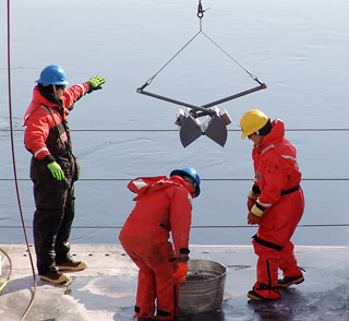
Solar Still

The diagram above exemplifies how a solar still works. Using heat from the sun, and the moisture in the ground, pure water vapor condenses on the plastic sheet and flows right into the container underneath. This can produce up to 1 pint of water a day if done correctly.

An alternate form of a solar still is done by collecting green leaves and stuffing them in a plastic bag. You then connect the bag to the end of a tree branch, in an area with sun light. Condensation will soon start to form and water is collected in the bag.

There are also plants that naturally store water called succulents. The most commonly known succuelents are cactuses. You can collect succulent plants and retrieve the water that is inside them.

Being hydrated is crucial for survival, so conserving the water you collect is not of much significance. Digestion of food requires the use of water, so minimizing your food intake when low on water is really helpful. Learning all of this information about obtaining safe drinking water made me a lot more comfortable with being in the wilderness. There are so many tools (whether you bring them with you or find them in nature) that can be used to filter water.

Once Kyle's presentation concluded, we left New Hampshire and headed for the Food & Water Watch office of Portland, Maine. Here we had a discussion with three women, all with some involvement in the water, food, and the legislation pertaining to water and food, of Maine.

Nhisa Swinton is organizer of the Food & Water Watch in Maine. Nhisha's goal is pass legislation that gets water to be considered public trust, rather then privately owned. Unfortunately, Maine is susceptable to the 'revolving door policy.' The revolving door policy is when rotation of personnel between  working for an industry and working for the section of the government who regulates that industry. Nestle is the corporation that seemed of most concern to Nhisha. CEO's of the Nestle in Maine have now rotated into environmental legislative roles. These people are obviously going to put leanient  environmental legislation in place that does not cut into their revenues. Nestle, the multinational water bottler which owns Poland Springs, has 11 wells and two bottling sites in Maine. They extract millions of gallons of groundwater each year from communities throughout the state of Maine. Establishing groundwater in the public trust would help protect groundwater resources from degradation and harm by placing its ownership in the hands of the collective public. Doing so would make it more difficult for bottled water companies to extract large quantities of water. Through numerous projects Nhisha, and the Food and Water Watch organization, work to protect the water that the people of Maine deserve.

Lisa Fernandes spoke next. Lisa is the organizer and founding member of Portland Maine Permaculture and the Director of The Resiliance Hub. She is a permaculture designer and teaches people how to impliment permaculture to their lives. What's permaculture? Permaculture is a design system and set of techniques that allows for truly sustainable human habitats and healthy ecosystems. Permaculture draws from organic farming, agroforestry, integrated farming, sustainable development, and applied ecology.


Through community involvement, Lisa strives to get more food from Maine onto the plates of Maine's people. About 80% food in Maine is imported which forces them to be dependent on fossil fuels. What will happen to the people of Maine if they no longer have access to fossil fuels? Permaculture allows for completely self sustaining food supplies. So, in the case of an oil crisis, people will not go hungry. Lisa's Resiliance Hub organizes activities such as  workshops, work parties, full permaculture courses, conferences, guest speakers, movie nights, and field trips, to educate people sustainable living.

The number of farms in Maine are growing. Maine is also home to the largest and oldest Organic Farming Association in the United States. Lisa seems to be hopeful for Maine's conversion to permaculture, and I think she should be. People across the country are starting to know what permaculture is and how beneficial it can be to them.

Next, we heard from Erin who works for Congress woman Chellie Pingree. Chellie represents the 1st district of Maine and has been an organic farmer all of her life. The piece of legislation that these women wrangle the most is the Farm Bill. This bill defines all of the agriculture policies in the United States. Here is where you will find all of the subsidies given to certain types of crops and farmers. Crop insurance subsidies give farmers and ranchers a safety net payment  in the event of bad weather or other crop damage. This doesn't sound so bad, we're protecting our farmers and therefore the food that feeds American people, are we not? No. The farmers benefiting from these subsidies are not small town farmers working to provide their families with income. Only ten percent of the farms in the United States collected 75 percent of the subsidies given out. An act of Congress in 2000 prohibits the release of information about who those farm subsidy recipients are and how much they receive each year. But, you can be sure that the farms collecting these subsidies are the large, industrialized farms with the biggest income levels. Corn, wheat, and cotton are the top three subsidy recieving crops. Corn, to feed our livestock, wheat to feed us with carbohydrates we don't need, and cotton to make clothes we unnecessarily buy.

To combat the issues caused by the Farm Bill, Chellie Pingree has introduced the Local Farm, Food, and Jobs Act. Her provisions to the Farm Bill hope to shift away from large agriculture and convert to local agriculture. The Local Farm, Food, and Jobs Act will provide local farmers with the resources they need. It will also implement school programs which promote more sustainable living. For example, chefs can go into schools and provide training for food service workers, wellness programs, cooking classes and more. These chefs can be a powerful tool in teaching kids healthy eating habits. Programs can have kids going outside to learn how to grow their own, healthy, sustainable foods rather then just pick up a tray of fries in the cafeteria.


Among the provisions of the Bill, schools can use a percentage of their federal commodity funding to buy local food. Rather than buying something from the Midwest that comes trucked in a can, they could be supporting the farmer down the road.

In addition to this, the Bill will allow for SNAPS (formerly known as food stamps) to be accepted at local produce businesses. SNAPS are used through swipe technology, which only large scale stores have the amount of money to purchase. 30 million dollars comes into Maine for food assistance programs and the Local Farm, Food, and Jobs Act will allow that money to be spent here in Maine at local food stores.


Hearing from these women was really inspiring. They are all working hard to promote the health of their states environment and the people in it. We got to hear about the legislative aspects of sustainable living in Maine from Erin, and how sustainable living is being implemented by Lisa. To see people in the legislature and the people of the state actually agree and work towards a common goal is really amazing.

We then left Portland, and headed for the Blackwoods Campground of Acadia National Park.

June 18th, 2012

We left Vermont today and drove to the White Mountains in New Hampshire. We set up camp at the Crawford Notch and then went for a hike on a near by trail. Along our hike, we stopped to hear a lecture about the 1973 Endangered Species Act from professor Patrick Hossay.

The purpose of the Endangered Species Act is to protect and recover at risk species and the ecosystems upon which they depend. The U.S.Fish and Wildlife Service and the National Marine Fisheries Service are the enforcers of the Endangered Species Act. Terrestrial and freshwater organisms are the responsibility of the Fish and Wildlife Service, while marine wildlife is the responsibility of the National Marine Fisheries Service. This Act allows for any person to report a species as being endangered or threatened. Once reported, the federal government must then determine to actually list the animal or not. Their decision to list an animal as endangered or threatened is expected to be based solely on their biological status and threats to their existence.Only the best scientific information available is expected to be used through out this process. 

There are five factors to be considered when evaluating a species for listing: 1) damage to, or destruction of, a species’ habitat; 2) overutilization of the species for commercial, recreational, scientific,or educational purposes; 3) disease or predation; 4) inadequacy of existing protection; and 5) other natural or man made factors that affect the continued existence of the species.  If listed, a species' critical habitat must also be defined. Critical habitat is not just a species current location, but anywhere that is essential to its conservation. For example, areas that species use during migration or reproduction could be deemed critical habitat. 

Once listed, a recovery plan to return the species to ecological health is composed. A recovery plan identifies the long term conservation strategies and gives detail of the specific actions needed to recover a listed species. Recovery actions may include the reintroduction of a species into formerly occupied habitat, habitat restoration and protection, landowner agreements that preserve or enhance habitat, land acquisition and management, population assessments, and captive breeding.

Unfortunately, some of the steps in the rehabilitation process are not always carried out with the species' best interest in mind, if they get carried out at all. Defining a species critical habitat and creating a recovery plan is usually interrupted by people or organizations with economic interests in the situation. Two-thirds of federally listed species have a portion of their habitat on private land. This has lead to serious complications with developers and home owners. This can be seen in the case of New England cottontails. Originally found in seven states, the range of this rabbit has now been reduced by more then 75 percent. The New England cottontail's ideal habitat are premature forests, which are now growing old and no longer a good habitat for them. Development of the forests in which New England cottontails reside is also a problem. White-tailed deer have greatly increased in the North East, and consume many of the same foods as the New England cottontail. Invasive shrubs are dominating many of the patches that these rabbits reside in. The most significant threat to New England cottontails are eastern cottontails, which, ironically, look exactly alike.

Image showing how similar the two species of rabbit are.

Eastern cottontails range has now dominated that of the New England cottontails, and has virtually replaced them. As you can see in the picture above, these rabbits are extremely similar in their external characteristics. However, when examining skull morphology or genetic samples, the difference between the two is obvious. So, it is reported that the New England cottontails are in trouble and the Fish and Wildlife Service starts examining the situation. Enough information is gathered to propose the species for listing, but is deemed only 'candidate' status. This means that the Fish and Wildlife Service recognizes the threats facing the New England cottontail, but species of higher listing priority must be dealt with first. Property owners of potential critical habitat areas for the New England cottontail are not in favor of this. No rabbit, especially one with a practically over populated twin in the same area, should stop them from doing what they want on their own property. Developers and property owners who have a stake in the situation will fight viciously to keep that species from being considered endangered.. The Fish and Wildlife Service try to give developers and property owners incentives to cooperate with them and protect endangered or threatened species. For example, in the case of the New England cottontail, the Fish and Wildlife Service are working with state governments to make sure no additional regulatory tasks will be asked of cooperating landowners should the New England cottontail be formally listed as a threatened or endangered species in the future.

Other cases exemplifying the legal problems between property owners and enforcing the Endangered Species Act include...

The Canadian Lynx
Lynx
Canadian Lynx.

In the 1970s and 1980s, the threat to lynx from trapping reached a new height when their hides became in high demand. The most suitable lynx habitat in is on public land. This includes national and state forests, where logging and recreational development often occur. Torn between industry pressure and science, Fish and Wildlife Service declined to list the lynx, despite the fact that three out of four FWS regional offices favored its listing.

Gray Wolves
Gray Wolf.

Gray Wolves had been absent from the Yellowstone area for 70 years, up until their reintroduction in 1996. Wolves are viewed as a nuisance to some people of the Yellowstone area, which brought controversey to the situation. Ranchers fear large losses of income due to wolf predation. Though many people visiting Yellowstone National Park will never see a free ranging wolf, Ranchers are continually subjected to livestock losses and wolf harrassment. These wolves are currently protected under the Endangered Species Act, however, ranchers of the area still fight to get that changed.

Although a good piece of legislation, the Endangered Species Act faces so much opposition that it cannot be used to its full potential. The process of listing a species takes incredibly long, and as I discussed above, it is corrupt. Federal, state, and local governments, usually stay true to their word on not providing funding for projects that interfere with endangered species and their critical habitats. For many states, and their inhabitants, hearing the words, "You can't do this on your land because there is an endangered species here, or because this is its critical habitat" does not go over well. They are citizens of America, free to do as they please on their own land. Changing the mind set of people like is probably the only way the Endangered Species Act can be fully utilized. I feel by educating of the people, and our legislators, on the importance of these species is necessary. Then, maybe the Endangered Species Act will face less opposition.

June 17th, 2012

Today we discussed Silver Lake in Goshen, Vermont, and the low-impact hydroelectric project there. 


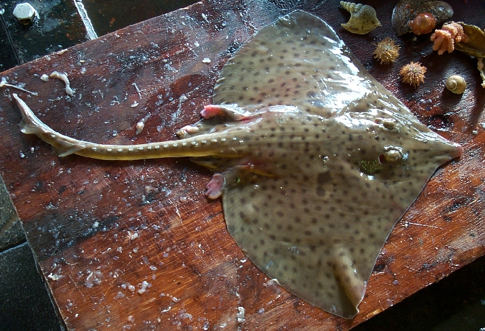
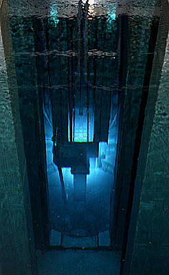
 The Sugar Hill reservoir covers 74 acres and is impounded by the Goshen Dam. Although not an exact representation of what happens at Silver Lake, the picture to the right may give you a general understanding of how hydroelectricity is produced. Water is released from the Sugar Hill reservoir through a 232-foot long, 4-foot square conduit outlet structure equipped with steel gate valves, and is then discharged to the Sucker Brook diversion dam. Sugar Brook is located about 2.6 miles downstream of the Goshen Dam. The intake structure at Sugar Brook dam is equipped with a wooden headgate and trashracks. The reservoir discharges into a 7,000 foot long penstock. From there, water discharges into a concrete raceway which extends 380 feet to Silver Lake. Water then enters the powerhouse at Silver Lake, which contains one 2.2 megawatt turbine generating unit. The powerhouse discharges into a 450 foot long tailrace that leads back to Sucker Brook. Power from the project is transmitted through a 6.9 kilovolt transmission cable that is connected to the regional grid. 

The most intriguing part of the Silver Lake Project is that no water is wasted through out the process. The water that is originally taken in will discharge to the Sucker Brook dam, about 450 yards upstream of where the brook enters Lake Dunmore. The water is returned to its natural flow and none of it is wasted! However, this project is very small when compared to others, which is why it is considered low impact. Low impact meaning that is has little impact on the environment. This project only produces 2.2 megawatts of electricity, while the project at Niagara Falls produces 498 megawatts. That does not make the project a waste. It still supplies 820 households with electricity annually. Also, when wind energy is in excess, it is stored on the grid at Silver Lake and expedited when needed. Although small, the hydropower project at Silver Lake should not go unappreciated.


After leaving Silver Lake, we headed for the Walmart of Rutland, Vermont. Usually, Walmart stores are built miles away from a town's center. Business is then dragged away from the local downtown stores and concentrated in the Walmart area. The towns small businesses are then destined for failure, leaving behind vacated buildings and unemployed towns people. When Walmart expressed interest in building a store in Rutland, the city took action. They knew the threat Walmart posed to their town and decided to take a different path, with similarities to new urbanism. Rutland incorporated the Walmart into their downtown by making it their anchor retail store. This Walmart does not add to sprawl and, rather then developing virgin land, used existing buildings in its formation. Instead of a super-sized Walmart, this one is sized at a suitable magnitude for the site location and the community. In addition, this Walmart appears to have no unfavorable impacts on natural resources.

The Rutland Walmart is certainly a success story. The city avoided what could have been complete devastation of its downtown and the small businesses that reside there. This certainly set an example for how other cities can welcome companies like Walmart while still keeping their downtowns in tact. It seemed as though Rutland was trying to implement some aspects of new urbanism with this Walmart. However, the downtown area still seemed a bit run down. The area was no where near as lively as Burlington. Still, the city of Rutland handled the Walmart situation with consideration for their towns economy and also the environment. Cities should follow their lead on projects similar to this one.


Leaving Rutland, we headed to Fair Haven, Vermont to see Daniel's maple syrup operation. Daniel has a quant maple syrup operation going in the woods located right next to his house. He has 200 taps in place, and collects about 20 gallons of syrup on a good year. The best kind of weather for collecting sap is when the days are warm and nights are cold. The month of March through April or May is the average time of year for making maple syrup.
The picture above was not taken at Daniel's operation, but is similar to what he had in place. Daniel's system is gravity fed, which means the trees he taps are on a slope so all their syrup flows downward into a common container. Daniel explained that it takes 40 gallons of sap to make 1 gallon of syrup. He prefers to tap Sugar Maples rather than Red Maples because their sap has a higher sugar content. Since originally tapping the maple trees five years ago, Daniel has not seen any significant change in the trees. They appear to be as healthy as they were when he started tapping them. What makes Vermont maple syrup the best? Daniel says its the rich soil and healthy trees. Making maple syrup is a common hobby in Fair Haven which made it easy for Daniel to pick up on it. He talked with fellow maple syrup makers and observed their systems in order to know what he was doing. 

Visiting Daniel's operation was nice because I got to see the work that goes into making maple syrup. Daniel made it seem simple, but it is still work. Seeing someone similar to my age practicing such a craft was inspiring. If more people had small operations like Daniel, maybe the need for large scale maple syrup would go down. I would rather purchase maple syrup, rather all my food products, from someone like Daniel over a big company.

Tonight we are camping off of Lake Bomoseen, which is Native American for clear water. We enjoyed a refreshing swim in the Lake and a fun game of volleyball. 

June 16th, 2012

Today we left the Adirondack's and went aboard the ferry across Lake Champlain into Burlington, Vermont. Once in Burlington, we went to Local Motion and rented bikes. Our professor, Patrick Hossay, then led us on a tour through the city of Burlington. On our tour, we stopped to talk about new urbanism and how it is utilized in Burlington. New urbanism is an approach to development that minimizes sprawl. Sprawl is when the necessary components of a community are spread out, and not in close vicinity to one another. These necessary components include schools, super markets, clothing stores, housing areas, and any other facility used in basic, every day life. When sprawl occurs, people are forced to drive more since these every day places are too far to walk or bike too. Burlington, however, has implemented many new urbanism tactics in order to combat sprawl.

In Burlington, biking and walking have been made the preferred methods of transportation. Places people go for their every day needs are within walking or biking distance. Newly urbanized communities, like Burlington, bump out the road ways, making it narrower. This signals to drivers that they are in a town center, and to drive with caution. Instead of painting lines on the street, newly urbanized areas will add texture to crosswalks with pavement or brick, making drivers more aware of pedestrians. During our day in Burlington, the mains roads going through the town were blocked off, so pedestrians could fully enjoy a festival that was taking place. The streets were covered with people, walking from store to store. A farmers market was set up, providing the people with some locally grown foods. People did not have to worry about walking through town and getting toppled by a distracted driver. This brought a feeling of safety to the town of Burlington, as I'm sure it does in most newly urbanized communities. 


Downton Burlington.

 Riding a bike is considered equal to driving a car in Burlington. This is a commonly used tactic in communities practicing new urbanism. There are specific bike lanes which you are required to use, and you must ride single file, just as cars would. Riding on the side walk is illegal. When bike riding, you are also subject to the same laws a person operating a car is. This means using hand signals to signify turning, and stopping at red lights. This all took a bit of getting used to while we were on our bike tour. If you are making a turn on a bike, you must get into the same turning lane the cars are using (after making the appropriate hand signal, of course).  Coming from a community that has not implemented new urbanism, this was all a bit terrifying to me. Police heavily enforce these laws and will issue you a citation for breaking them. 

The housing in Burlington also demonstrated new urbanism. There is no real separation between low income housing and middle or high income housing. All types of housing were integrated amongst each other, forcing people of different social classes to interact with one another. Rather then the typical cookie-cutter neighborhoods, Burlington has a variety of types of housing to give it a more aesthetic feel. Some communities of new urbanism will hire multiple developers, so the area can have all different styles of housing. In Burlington, we saw apartments, houses, and town houses, all mixed together. There are also a good amount of trees and plants placed through out Burlington. This gives the area a small town feel. 

Another goal of new urbanism is to reduce the amount of brown and gray fields. A brown field is a patch of land that is undesirable for development due to some sort of contamination. The area may have previously used as a gas station, or landfill. A gray field is an area that has been previously been developed, but has since been abandoned. Good examples of gray fields are abandoned Wawa buildings or factories. To redevelop a gray field costs significantly more then to develop an untouched patch of land. This makes development much more harmful for the environment then it needs to be. 

New urbanism is an excellent approach to development. People will be drawn to the town center, as was seen in Burlington, and generate economic activity. Yet, the town will be practicing more environmentally friendly tactics such as biking or walking rather then driving. New urbanism brings a sense of dedication to the people of the community. Rather then being secluded in their cars and gated communities, people are walking about and interacting with one another. This allows for people of different races, ages, and economic background to become familiar with one another. People living in areas that become segregated by race or income level have a fear and misunderstanding of one another. This is much less prevalent in communities of new urbanism. Unfortunately, the zoning ordinances of towns are usually restrictive, and do not allow for new urbanism. A towns zoning ordinance is the official plan of land use policies for a city, district, or county. An ordinance specifies where and how land will be used. An area can be put in the category of residential, industrial, agricultural, light industrial, commercial, high density residential, or other types of land use. 
 The zoning ordinances in a lot of towns has led to an incredibly wasteful, expensive way of living. When deciding how to zone, town legislators are going to do what will bring in the most revenue; large, identical houses, and lots of them! "Bigger homes can bring a lot more tax money to a small town that doesn't have much of a commercial tax base" says Christopher Solomon of MSN Real Estate. The worst part is that there is growing
evidence that people do not even want houses this large, but that is all that is being built. Through out the country is a McMansion backlash, claims Solomon. People living in these neighborhoods cannot ride their bike to work, they have to drive. Children cannot walk to school, they have to be picked up by a bus. Everything is sprawled across town. Low income housing is isolated from the McMansion owners. There is going to be little sense of community involvement and dedication. Changing the zone ordinance of a town is a hard process. The trick is to zone for new urbanism from the beginning, as Burlington did. The only way new urbanism will spread is if people show their town, district, or counties representatives that they want it. After visiting Burlington and experiencing new urbanism, I do not want to live anywhere that has not implemented it.


 After our tour of Burlington, we headed the the Ben and Jerry's factory for a tour. We got to learn the history of the company, as well as how the ice cream is actually made. The companies founders, Ben Cohen and Jerry Greenfield, believed in taking social responsibility for their company. The dairy products they use are locally made, they hire local employees, and use Fair Trade ingredients. If something is titled Fair Trade is means that the farmers who grew the ingredients received a fair price for their harvest, and, in return, agree to use environmentally sound farming practices, implement fair working standards, and invest in their communities. Ben and Jerry's is a really good model for how companies, whether producing ice cream or not, should be run. They promote good moral values while still making a profit.


Tonight we are camping right off of Lake Champlain in Vermont.

June 15th, 2012

Today we hiked Mount Tabletop of the Adirondack's. Along our hike, we came across what was left of a hundred year old dam, destroyed by Hurricane Irene. Dams are generally not a good idea for multiple reasons. One, they block movement of fish and other species. Some fish migrate from rivers to oceans, and vis versa, to reproduce. With a dam in the way of their travels this cannot happen. Also, dams block fish and other aquatic species from interacting with one another. This can cause genetic malfunctions because fish will start becoming inbred. Dams are also known to cause floods and block sediment from flowing. A change in water temperature can also be caused by a dam. The water at the top of the dam is easily reached by sunlight, while the water flowing down stream is not as easily reached. Therefore the water at the top of the dam has higher water temperatures and can support more bacteria and phytoplankton. Dams also disrupt the native habitat of an area, especially wetlands.

As we continued our hike, we came across a massive rock with a tree growing out of it.

Tree growing out of rock, similar to what we saw in the Adirondacks.

 At this point, we stopped to talk about soil formation. There are five factors to soil formation....

1) Types of soil vary depending on the type of climate. Wind redistributes sand and other particles especially in arid regions, temperature and moisture amounts cause different patterns of weathering and leaching. The timing, amount, intensity and kind of precipitation influences soil formation. The changes in seasonal and daily temperature affects rates of chemical reactions, moisture effectiveness, kinds of vegetation, and biological activity.

2) The topography of an area, which is the physical layout of the land,
affects the temperature and moisture levels of soil. If soils are on steep slopes, facing the sun, they are going to experience warmer temperatures. Steep soils may be eroded and lose their topsoil as they form. This may then cause them to be thinner then soil on a level area. Soils on the bottom portion of the land can be expected to be of darker color.

3) The material in which soil forms is known as parent material. The parent material of soil may be rock that it decomposes from, or material that has been deposited by wind, water, or ice. If formed from a decomposed rocks, these “residual” soils will have the same general chemistry as the original rocks. Most commonly, soils form in materials that have moved in from elsewhere. The character and chemical composition of the parent material plays a crucial role in determining soil properties, especially during the early stages of development. 

4) Biological factors, such as plants, animals, micro-organisms, and humans, also play a role in the formation of soil. Leaves that fall from plants to the surface are decompose into the soil with help from certain organisms. The organisms decompose these leaves and mix them with the upper part of the soil. Different types of roots have different effects on soils. Trees and shrubs have large roots that may grow to considerable depths and open pathways in the soil. Grass roots contain many fibers near the soil surface and easily decompose, which adds to organic matter. Taproots are straight tapering roots that grow vertically downward and form a center from which subsidiary rootlets grow and open pathways through dense layers. Micro-organisms in the soil can also affect chemical exchanges between roots and soil. The feces of animals, and also their bodies when they die, are decomposed into the soil. Humans are capable of mixing the soil so extensively that the soil material can again be considered parent material.

5) Lastly, time for all of these factors to interact with one another is a factor. Soil is constantly being blown or washed away. If a flood washes in a new layer of soil, the soil formation process starts over again. Say an area lacks biological activity, then it is going to take a longer amount of time for the soil formation process to complete there. The topography of an area is also constantly changing which delays the soil formation process. Time, for nature to take its course, is necessary for healthy soil to form. 

The fact that a tree is capable of growing out of a rock is incredible. They are able to do so because they create their own food through the process of photosynthesis, explained in the diagram below. 
 
The rock that the tree had sprouted from also had lichen on it. When algae and fungus physically intertwine, an entirely new growth called lichen is formed. Lichen is simply strands of algae that are connected with roots and branches of a fungus. The algae portions of lichen contain chlorophyll (similar to the plant pictured above), which makes it able to photosynthesize and feed the fungus aspects of the lichen. The fungal roots in the lichen leech water and minerals from the rock, which in turn feeds to algae. The algae and fungus could not survive independently in this environment, so they work together to survive.  Lichen slowly erodes the rock, or other surface, it thrives on. Lichen is referred to as the initial colonizer of the environment. It provides the tree growing out of this rock with a basis for life. 

Lichen, similar to what we saw in the Adirondacks.

Our original plan was to hike the tallest mountain in the Adirondack's, Mount Marcy. However, we ended up hiking one of the smaller mountains, Mount TabletopThe trail on Mount Tabletop was unlike any trail I had hiked before. It was a real trail; narrow, windy, with lots of mud and wetness. Along the hike we saw some cool wildlife such as a leopard frog, a salamander, and even some bear tracks in the mud.

After our hike, we went into the town of Lake Placid. This town seemed very active and alive. People were walking the streets, entering the stores and restaurants. Lake Placid, and the people in it, seemed to have a strong interest in fitness. The 1980 winter Olympics were held in Lake Placid which I think is the root of their interest in fitness. While we were there, a local bike shop was welcoming  the contestants of a bike race they had planned for that weekend. Bicycling seemed to be of common interest in Lake Placid, whether that be for transportation or sport. We left Lake Placid and returned to our camp site in the Adirondack's. While hanging around our site, we actually heard coyotes howling in the distance. This was our last night in the Adirondack's, and thankfully, we made it through with no visit from the coyotes.